Day 2
February 8, 2010
University-Spadina Line
17.0 Kilometres
Once again I left with Ursula in the morning. This time at Youge we parted company, she heading north and I heading south. I took the subway down to Union Station, where I left off last time.
Union to St. Andrew
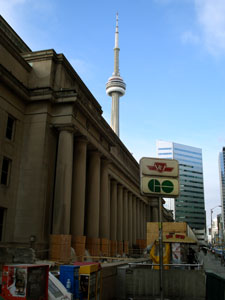 As I emerged from the subway at Union Station it was a bright sunny day. It was cold, but it seemed warmer than last week. Probably because there was no wind. I headed down Front Street. Across from Union Station is the venerable Royal York Hotel.
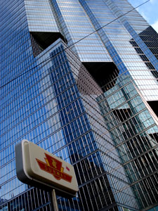
I turned up University Avenue. This is the glass skyscraper part of town. It's the financial center, and I was walking along with people on their way to their offices in the towers.
St. Andrew Station is on King West, amongst the financial institutions. Half a block away is Roy Thompson Hall, where I have seen such acts as Philip Glass.
St. Andrew to Osgoode
 Heading up University we come to the new opera hall, which I have never been to.
University is a wide street, with a large boulevard separating the north and southbound lanes. At this point there are sculptures in the boulevard.
Osgood Station is on Queen Street West. Queen West was the trendy part of town when I first moved here. Now it's all become yuppified.
Osgoode to St. Patrick
Looking the other way down Queen, you can see City Hall, which you may remember from an episode of Star Trek: The Next Generation.
This brings us to the insurance company area of town. Nestled in here is the American consulate, site of many a protest.
The farther north I went the stronger the wind became and the colder it got. Like last week, my hands became numb when I took pictures.
The boulevard here is a park with grass and benches to sit on. I suspect it doesn't get much use.
Saint Patrick Station is on Dundas Street West. The overflow of Chinatown is along here.
St. Patrick to Queen's Park
We're back to statues in the boulevard.
This brings us to the hospital area of town, including Sick Kids Hospital.
Queens Park station is right on the edge of the University of Toronto campus, so there's a steady stream of students emerging from the subway.
Queen's Park to Museum
Queen's Park station is named for Queen's Park, where the Ontario Provincial Parliament is. University splits here, with the north and southbound lanes going on either side of Queen's Park, and its name changes to Queen's Park Cres. I walked up the west side, which bordered on the U. of T.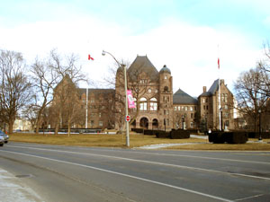
On the north side I decided to cross over to the park. I walked through the park to the point where both halves of University rejoin.
Museum to St. George
Museum Station is right in front of the Royal Ontario Museum. Right beside it is the MacLachlan planetarium, which the Mike Harris government shortsightedly shut down. The last thing I saw there was a Star Trek exhibit. There were many busloads of children waiting to go into the museum.
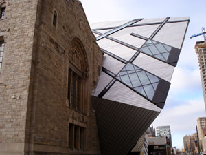 At this point the subway makes a left turn and follows Bloor Street, paralleling the Bloor subway line. When I turned the corner as wind got even colder. Here you can see the new crystal addition to the ROM. I think it looks really ugly. Like some sort of alien is devouring the building. I decided to get out of the cold by going into the Museum Shop. The sign said it opened at 10:00. I looked at my watch, but it wasn't working. The batteries have been wearing down. I pulled on the door, but it was locked. I kept walking.
I went past the new Varsity Stadium. The former Varsity Arena also used to be here. That's where I saw Dire Straits. The acoustics were terrible.
Past the Bata Shoe Museum to St. George.
St. George to Spadina
The U of T campus continues to the south of us.
At Spadina the Bloor and University-Spadina lines again diverge with the University-Spadina line heading north up Spadina. This is an area of small, specialized schools. There was a library, so I was going to duck into it to warm up, but it was closed on Mondays.
Several blocks up Spadina are more entrances to the Spadina Station. This is where the platform for the Spadina line is. There's a long walk between the platform on the Spadina line and the platform on the Bloor line. There used to be a moving sidewalk between them, but it kept breaking, so they dismantled it several years ago.
Spadina to Dupont
Next comes an area of high-rise apartments. I knew a couple of people who lived in these. This is followed by a residential area. Then we come to Dupont Street.
Dupont to St. Clair West
North of Dupont, Spadina goes under the tracks. On the other side I discovered the Toronto Archives. I went inside to warm up. They had displays of old photos of Toronto. They also had a special exhibit on public health in Toronto through the years. You could look through a window to see the massive warehouse of stored material.
When I left the archive building it seemed much warmer out. This was probably because I was at the foot of a hill, which blocked the wind. Spadina ends at the foot of this hill, on top of which sits Casa Loma. This is Toronto's castle. I climbed the stairs to the castle. At the top of the hill the wind resumed. Spadina starts up again on the other side of the castle.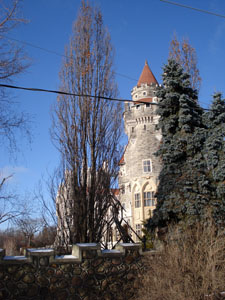
A guy on a mountain bike rode up to me and asked if there was a park nearby. I said I didn't remember there being a park, but it was many years since I've been here.
I walked through the residential area, and sure enough there was a park. I had forgotten about it. It's built on top of a water reservoir. When I lived in the neighborhood I would walk here and take pictures for the photography class I was taking.
I went down into the ravine heading away from the park. It's a little forested area, with fancy homes and high rise apartments backing onto it. The path through the ravine leads to my favourite subway entrance. The entrance leads into this wooded ravine. However, it's never open.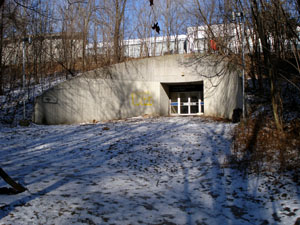
The path leads up to the surface at St. Clair. I used to live a block away from here. Across the street from the subway station, the Loblaws has been completely rebuilt since when I lived here.
I needed to get to Heath Street from here, so I walked through the Loblaw's parking lot. Then through the St. Michael's Arena parking lot. I used to play hockey here. There's another's subway entrance here on Heath Street.
St. Clair West to Eglinton West
From here I descended into another wooded ravine. It goes for quite a ways and then opens into a big park. I've cycled this many times with the club. By this point I was hungry. It would've been a perfect place to stop and have lunch in the summer.
Than you're spit out into a residential area that was slated for demolition back in the 70s. I walked up the street to the Eglinton West station.
Eglinton West to Glencairn
At this point the subway emerges from the ground. It runs between the north and the southbound lanes of the Allen Expressway. The Allen Expressway was supposed to extend all the way down to the lake, but local community activists stopped it.
There are sidewalks that paralleled the Allen and the subway, separated from them by sound barriers. I've cycled this many times with the club. There are cross streets that run over top of the Allen and the subway. Amazingly, considering how wide and open it is, there was little wind.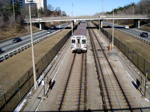
It runs through a residential area. The sidewalk ends at an area of high-rise apartments. I walked along the road that serviced these apartments. But then there's the Bell building so you can walk no further. I took a cross street across to the east side where there was a sidewalk.
Mark had a rule that he had to touch every subway station. Since I've been in and out of all of them, I don't have that rule. but there's a good chance that I've never been in or out of the Glencairn Station, so I did touch the south entrance to it. On Glencairn is the north entrance.
Glencairn to Lawrence West
At this point I once again had to switch to the west side of the street. I got to a point where house yards were fenced off right to the barrier. So I had to go to the next parallel street. After one block I could return to the barrier beside the expressway. This was an area of lowrise apartment buildings.
I followed the sidewalk to Lawrence, where I tagged the station as I have not gotten on or off here either.
Lawrence West to Yorkdale
I was starving so I went into the Lawrence Square Mall, found a bench across from the pet store, and had lunch. I looked at my watch and it was working again, so I didn't look for a new battery.
After eating I walked through the parking lot until I could go no further due to fences, and had to cross over to the east side again. I walked through an area of low rise apartment buildings. I hoped there would be access to the Yorkdale subway station from this side. There was, at the south entrance.
I crossed back to the west side, and entered Yorkdale Park. That led me to the rear of Yorkdale Mall. I went to the subway entrance. When my company moved to Markham, and I had to get a car, this is where I would pick up a coworker who didn't have a car.
Yorkdale to Wilson
From here is a walkway to Yorkdale Mall. My original roommate in Toronto worked here in a store called Gentleman's Court. It no longer exists. This was my default mall back then. It's been greatly expanded since those days.
I went to Michel's Baguette and got a cinnamon bun. This is part of my training for my bike trip across Canada. I've vowed to eat more cinnamon buns on the trip.
I left the mall and headed over to Dufferin Street in order to get under the 401. On the other side its big-box suburban hell. Then I walked through the TTC parking lot to the Wilson station.
Wilson to Downsview
From here you can't be right beside the subway, because the TTC switching yards, the Downsview Airport, and the Allen Expressway are in the way. So I headed up Wilson Heights Blvd. This goes through suburbia.
I passed a big field with what looked to be a TTC bus driver training area. I turned down a side street, which led to a field, which I crossed to get to the Downsview Station. The station was added a few years ago when they extended the subway from Wilson.
It's across the street from Downsview Park, which is Canada's first national urban park. It was Downsview Armed Forces Base, but it was decommissioned a few years ago. It was an Air Force facility. The airport is still there, but the rest is gone. I believe they've built houses on part of it. And there's a big area where they hold concerts such as SARSfest. Across the street is the Idomo furniture store, which flooded with sewage after they dumped the porta potty's after SARSfest and the sewers couldn't handle it.
I've been meaning to come to this station ever since they opened it. Today was finally my chance.
Epilogue
Using my hiking boots, I managed to do today's walk without getting any blisters.
I hopped the subway back home. I discovered that it is underground the first half of the way back to Wilson.
That night the battery in my watch died again, so I got a new one the next day.
Pictures and Text Copyright ©
2010 paul Stockton. All rights reserved.
Last updated: February 17, 2010